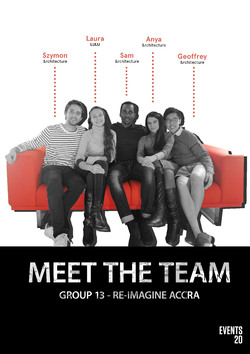
Meet our international team of five 5th year students. We are a group of creative and friendly students with different experiences and interests.
Anya: &Architecture
- My main interest relates to the usage of public spaces and their social value within the diverse cultures.
Geoffrey: &Architecture
- I am keen to know the social impact brought by urban development. I am passionate in photography and graphic design.
Sam: &Architecture
-I’m interested in a user-centred design and co-design in architecture. I also like long-boarding and making animations.
Szymon: &Architecture
- I am interested in the impact of political and historical context in a perception of urban fabric.
Laura: LULU
-I am interested in how architecture and urban planning shapes habitats and controls the built up environment.
Hope you are interested in our event and we are looking forward to meet you and work together on this project!
Posted 7 Mar 2020 14:44
-Accra Futurism Research Method-
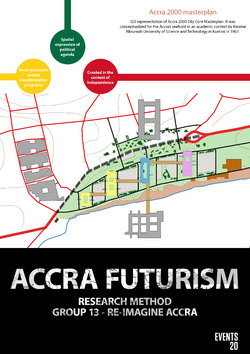
In order to map a unique moment in African architecture, Accra Futurism Research Method combined archival research and the use of digital tools, in particular GIS, to study the explosion of architectural production and urban imagination during the first decade of Ghana’s independence (1957-1967).
The hope and ambition for Ghana and for Africa more generally were given shape in the architectural production of the capital city of Accra under Kwame Nkrumah, Ghana’s first leader. The focus was on examining the city’s development, including both realised and conceptual design plans for Accra. While some of these designs were a continuation of the late colonial planning in the then Gold Coast, most were new developments involving new partners. By reviewing these different designs and their alternative approaches, was studied the competing architectural imaginations for Accra, which Nkrumah envisaged not only as a capital of the country but also as a political nucleus of the entire continent.
The aim of the research was to understand the urbanisation process of Accra in general from the second half of 20th century until today as part of larger cultural, political, economic, and social development of West Africa. Were developed knowledge of digital research and presentation tools, and a critical understanding of their uses and limitation within a broader debate about Digital Humanities and architecture as a knowledge-producing discipline.
Posted 16 Mar 2020 13:55
- SITE VISIT -
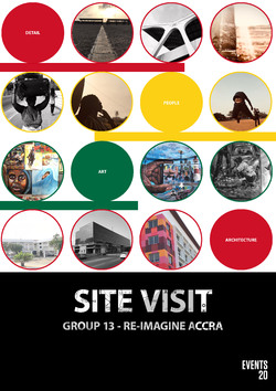
Many thanks to our collaborators who organised the trip to Accra to enhance the site essence. The pictures illustrate the true value of a site: human, art, architecture, and detail.
The pictures capture the social value of the marine drive waterfront, demonstrating that a site is not just a piece of vacant land; it is much more. It has human activities which define the space, it has monuments and building illustrating the country’s history and heritage, with beautiful architectural details.
Posted 22 Mar 2020 19:16
- SITE LANDMARKS -
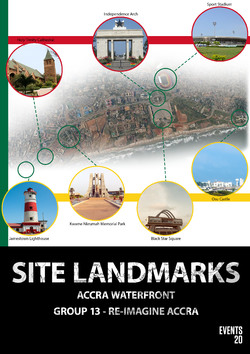
Accra’s waterfront is located in the city centre and is surrounded by numerous landmarks, enriching the capital with cultural heritages. Numerous of these monuments have been build after the independence, during the time of the first Ghanaian president, Kwame Nkrumah.
-Osu Castle: was built in the 17th century as a fortress by the Danish colony, being numerous time rebuilt during the years. The castle was used by numerous colonial rulers, nowadays being listed as a World Heritage.
-Holy Trinity Church was an Anglican Church built in 1894 and became Cathedral in 1909. It was founded by the British colonial government and it is one of the oldest church buildings in Accra.
-Black Square: was commissioned in 1961 by Kwame Nkrumah in honour of the Queen Elizabeth II visit to release the country into independence. This monument is created to illustrate the fought for Ghana’s independence in 1957.
-Independence Arch: is part of the Independence Square, and it is a grand gate, designed to be the symbolic entrance for the Memorial Park created for Nkrumah.
-Kwame Nkrumah Memorial Park and Mausoleum: is the resting place of the Nkrumah and his wife. Don Arthur designed the mausoleum as a peace symbol, illustrating an upside-down sward. The park has a museum showcasing rare artefacts related to the countries’ independence.
-Jamestown Lighthouse: is situated in the oldest district in Accra, Jamestown. It was built by British in 1871 and replaced in 1930’ by a modern structure existent today. It served as a light have for the British governors trading and administrative activities.
- Sport Stadium: was commissioned in the 1960S by Kwame Nkrumah to host national and international matches; the sport industry overgoing a great boom after the independence.
Posted 22 Mar 2020 19:18
- QGIS -
QGIS is a user friendly Open Source Geographic Information System (GIS) used for mapping, but not exclusively. The key features of this software are to create, edit, visualise, analyse and publish geospatial information.
Part of our event, we intend to introduce this system as an alternative mapping tool. We have invited a special technician to teach us and our Ghanaian collaborators, how to use this software and apply it to our project.
We intend to use QGIS for drawing up the existing waterfront and the new Marin Drive Project proposal. Based on the video relieved by the architects, being the only visual representation of the proposal, students will be divided into different groups to draw the data. The purpose is to illustrate how the masterplan will fit within its existing context, and compare it against historical masterplan proposals drown in QGIS by students from the Accra Futurism Research Method.